13 October 2026
Designed by researchers at Stanford University, Palladio allows users to visualize their data through spatial maps or network analysis with just a CSV. Since we have already worked with spatial data in this course, I focused on the network analysis tool in Palladio to enormous success.
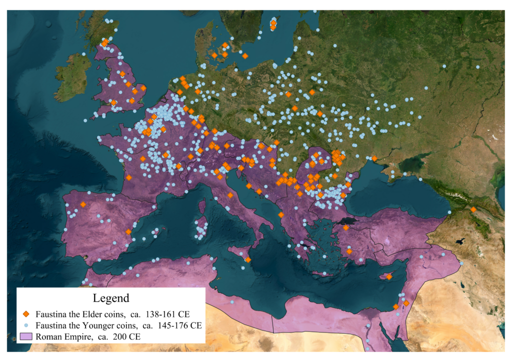
I elected to upload a pre-existing CSV dataset of Roman coins pulled from OCRE1 to play around with Palladio. I worked with this data spatially on a project that looked at ambiguities between Roman empresses and goddesses earlier this year2, but I have never considered examining the same data from a network analysis perspective. From a spatial vantage point, I wanted to see how far (geographically) coins of empresses Faustina the Elder (100-140 CE) and Faustina the Younger (130-145 CE) had spread across the Roman Empire. Running the OCRE coins datasets through QGIS revealed that the coins had spread significantly beyond the Italian peninsula (see map below).
But spatial data can only tell us so much. Running the same two datasets through Palladio’s network analysis tool allowed me to examine different aspects of the dataset in relation to one another. Particularly, I was able to plot the portrait on the obverse (the front/”head” of the coin) against the inscription on the reverse (the back/”tail” of the coin). This is significant because it allowed me to see the patterns between coins of the two Faustinas before and after they were deified3 in relation to the divine associations on the reverse of the coins. In the Roman Empire, it was common for emperors and empresses to issue coinage with their portraits (and names) on the obverse and images of gods/goddesses on the reverse–with accompanying inscriptions–to promote associations between themselves and the divine.
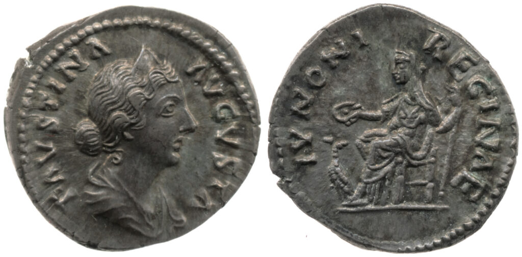
Obverse: Faustina the Younger, FAVSTINA AVGVSTA (“Revered Faustina”),
Reverse: Juno, seated with scepter and patera, IVNONI REGINAE
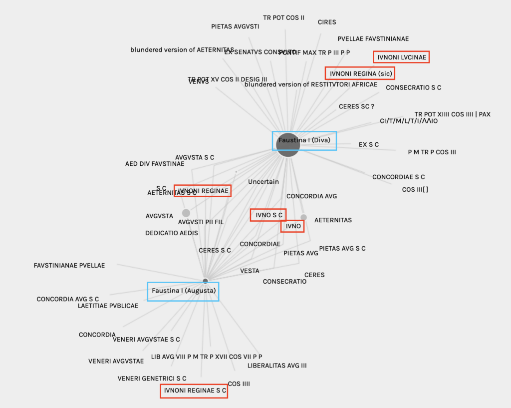
Using Palladio, I had the network analysis tool map the portraits on the obverse to the inscriptions on the reverse, generating the network below for Faustina the Elder. You can see the two central nodes in the network below, where coins issued before Faustina the Elder’s deification (which occurred upon her death in 140 CE) and after are shown as separate nodes. Faustina the Elder was referred to as “Faustina Augusta” initially, and later received the title “diva” (“Diva Faustina”) after her death. She died early into her tenure as Roman empress, which is indicated by the significantly larger node for “Faustina I (Diva)” in the network. I only included coins that were definitively classified as portraits of Faustina the Elder by OCRE in this analysis, so uncertain portrait coins were not included.
Data originally downloaded from OCRE (November 2024) and cleaned by author.
The connecting nodes between Faustina the Elder’s two titles indicate all of the reverse inscriptions found on coins issued both pre and post-deification. Some inscriptions are unsurprising due to their frequency across Roman coinage, such as AVGVSTA S C (Augusta senatus consultum4)and AETERNITAS (eternal), but others spark potential questions. Part of my original research project that started this network analysis was examining ambiguities between the two Faustinas and the goddess Juno, and strong associations can be seen in this network analysis. All instances of Faustina the Elder coinage issued with Juno inscriptions are highlighted in red in the above network, totaling six different variations across both of Faustina the Elder’s titles. Only one inscription, IVNONI REGINAE S C, is seen exclusively in the elder Faustina’s Augusta coinage. The bulk of the Juno-related inscriptions are either shared across both Faustina the Elder’s Augusta and Diva coins, or are exclusively found on her Diva coinage. This makes sense if we remember that the elder Faustina died early into her reign with Antoninius Pius, so the vast majority of coins issued with her portrait were post-deification.
Interestingly enough, the number of associations with specific Juno inscriptions is notably different between the Faustina Augusta and Diva Faustina coins. Filtering the network for only coins depicting Faustina Augusta on the obverse reveals that 114 of the 120 coins with IVNONI REGINAE were minted before Faustina the Elder’s death. Moreover, almost all of the coins with just IVNO or IVNO S C as the reverse inscription featured Diva Faustina portraits on the obverse, highlighting the shift in the elder Faustina’s association with Juno as a ruler to her association with Juno as a goddess.
| Reverse Inscription | Count |
|---|---|
| IVNO | 1 / 17 |
| IVNO S C | 2 / 27 |
| IVNONI REGINAE | 114 / 120 |
| IVNONI REGINAE S C | 1 / 1 |
| IVNONI REGINA | 0 / 1 |
| IVNONI LVCINAE | 0 / 7 |
| Reverse Inscription | Count |
|---|---|
| IVNO | 16 / 17 |
| IVNO S C | 25 / 27 |
| IVNONI REGINAE | 6 / 120 |
| IVNONI REGINAE S C | 0 / 1 |
| IVNONI REGINA | 1 / 1 |
| IVNONI LVCINAE | 7 / 7 |
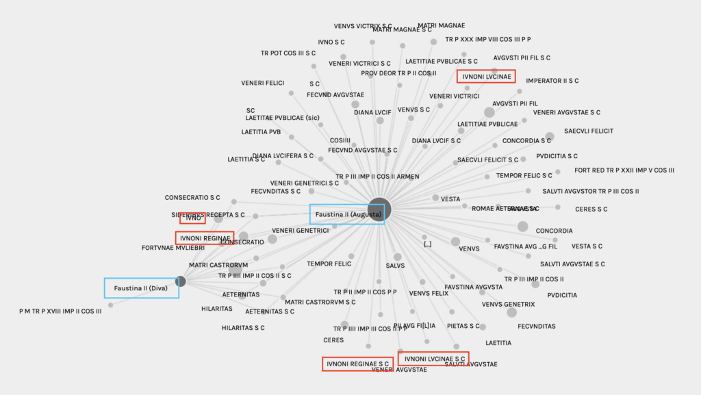
Faustina the Younger is a slightly different story. The daughter of the elder Faustina, the younger empress was alive for most of her husband’s reign so the majority of coins issued with her portrait were as Faustina Augusta, not Diva Faustina. (Faustina the Younger’s husband was Marcus Aurelius, r. 161-180 CE). She had few coins issued posthumously by her husband or successive emperors. This difference from the elder Faustina can be seen in the larger node for the “Faustina II (Augusta)” title in the network analysis below.
Data originally downloaded from OCRE (November 2024) and cleaned by author.
An examination of Faustina the Younger’s network analysis also shows that the younger Faustina was associated with significantly more goddesses and titles on her reverse inscriptions than the elder Faustina was. Juno made up a much smaller overall portion of inscriptions for Faustina the Younger than Faustina the Elder, suggesting that the younger Faustina’s imperial image was not as concise or universal as her mother’s.
Issues & Future Implications
As amazing as Palladio seems to be to work with, it isn’t without its issues. My biggest complaint about the platform is the lack of maneuverability in the network analysis tool. Palladio generates the network from a user’s dataset, but doesn’t actually allow them to manipulate the network once it is generated. Users can zoom in and out for better visualization, but there isn’t a way to rearrange the nodes. Moreover, Palladio doesn’t currently have image download capabilities, so users have to screenshot their networks rather than download them as a JPEG, PNG, etc. Since the networks can’t be manipulated, screenshots often have to prioritize capturing the entire network over readability–as evidenced in my networks above which have some overlapping node labels.
Looking forward, I would like to generate a network for the two Faustinas and the goddesses represented on the reverse of the coins to see if certain goddesses are more common than others. This would require a more significant cleaning of my preexisting datasets, which I didn’t have the time to do for this week’s assignment. OCRE doesn’t have a field in its downloadable data dedicated to the portrait/image on the coin’s reverse, so I would have to generate that myself. There is a reverse description field, but that is far too many words and far too specific for each coin to be put in a network right now. The reverse inscriptions have been a good substitute in the meantime, since they suggest the image on the reverse of the coin.
- OCRE: Online Coins of the Roman Empire, accessible at https://numismatics.org/ocre/. A similar database also exists for coins of the Roman Republic (Online Coins of the Roman Republic, CRRO, accessible at https://numismatics.org/crro/). ↩︎
- See “Between Goddess and Empress: Iconographic Ambiguities in a Roman Provincial Bronze” under “Research and Projects” tab. ↩︎
- It was common practice in the Roman Empire to deify emperors and empresses after their deaths, elevating them to the status of gods. These titles were often accompanied by official cult worship, such as the cult of Augustus or Temple of Septimius Severus at Djemlia. ↩︎
- S.C. = senatus consultum: by decree of the [Roman] Senate. S.C. is commonly seen on Roman coins. ↩︎